


Similar Products


Product Details
MSRP $699.99
MPN 010-02920-00
UPC 753759329709
Description
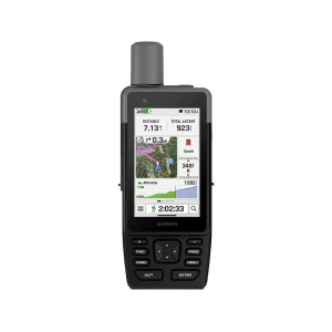
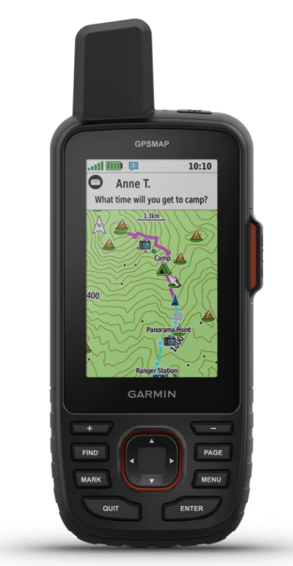
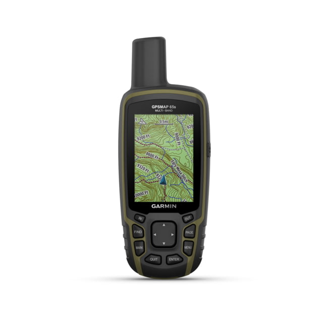
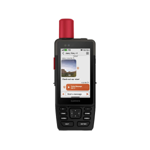
This rugged GPS handheld navigator has a modern design, preloaded maps and incredible battery life. It’s time to hit the trails.Introducing the Garmin GPAMAP H1 Handheld, a rugged and versatile navigator ready for any adventure. This device features a modern hybrid design with a bright, sunlight-readable TOUCHSCREEN DISPLAY and easy-to-use PHYSICAL BUTTONS. The 3.5-inch color touchscreen has chemically strengthened glass for durability, while the push-button interface provides more versatility for gloved hands or in adverse weather.Navigate with confidence using ADVANCED NAVIGATION that comes with preloaded TopoActive maps for the U.S., Mexico, and Canada. You can see terrain contours, elevations, and geographical points to help you plan and execute your trip. For enhanced detail, use Wi-Fi technology to download high-resolution SATELLITE IMAGERY directly to your device to find trails, pick stand locations, and create waypoints.For even more premium content, you have the option to purchase an OUTDOOR MAPS+ plan, which provides access to a variety of detailed mapping content updated regularly and sent to your device over Wi-Fi. With LOCATION ACCURACY provided by multi-band GPS and multi-GNSS support, you'll have superior positional accuracy to pinpoint your precise location, even in challenging environments.In the Box GPSMAP H1 Loop Carabiner Charging/Data Cable DocumentationGeneral Lens Material: chemically strengthened glass Dimension: 2.6" x 7.0" x 1.3" (6.7 cm x 17.9 cm x 3.3cm) Weight: 9.7 oz (276 g) Water rating: IP67 MIL-STD-810: yes (thermal, shock, water); bare unit only Touchscreen Display Type: transflective color TFT Display Size: 1.9"W x 3.0"H (4.7 x 7.7 cm), 3.5" diagonal (8.9 cm) Display resolution: 282 x 470 pixels Battery Type: rechargeable, internal lithium-ion Battery life: All Satellite Systems + Multi-band: Up to 145 hours*; Expedition mode: Up to 840 hours; *Assuming typical use with SatIQ technology Memory/History: 64 GB (user space varies based on included mapping) Interface: USB-CMaps & Memory Preloaded maps: yes (TopoActive, routable) Ability to add maps Basemap Automatic routing (turn by turn routing on roads) for outdoor activities Map segments: yes (15,000) Satellite Imagery: yes (direct to device) Includes detailed hydrographic features (coastlines, lake/river shorelines, wetlands and perennial and seasonal streams) Includes searchable points of interests (parks, campgrounds, scenic lookouts and picnic sites) Displays national, state and local parks, forests, and wilderness areas External memory storage: yes (1 TB max microSD card) Waypoints Courses: unlimited Activities: unlimited Activity profiles GPX imports Rinex loggingSensors GPS Galileo QZSS BeiDou IRNSS Barometric altimeter Compass: Yes (tilt-compensated 3-axis) High-sensitivity receiver GPS compass (while moving) Multi-band frequency supportDaily Smart Features Connect IQ (downloadable watch faces, data fields and apps) Smart notifications on handheld Weather Pairs with Garmin Connect Mobile Garmin Share Passcode Auto correct keyboard Safety and Tracking Features LiveTrack Safety sirenTactical Features Compatible with AB Quantam - Garmin Ballistics solver: yes (unlock required) Dual grid coordinates Night vision mode Outdoor Recreation Point-to-point navigation Spoken turn-by-turn directions TracBack Area calculation Sun and moon information Geocaching-friendly: yes (Geocache Live) Custom maps compatible: yes (500 custom map tiles) Picture viewer inReach remote widget LED beacon flashlight FlashlightinReach Features inReach remote compatible Outdoor Applications Compatible with Garmin Explore app Garmin Explore website compatible Dog tracking: yes (when paired to compatible dog track system)Connections Connections Wireless Connectivity: yes (Wi-Fi, BLUETOOTH, ANT+)